Alaska (
i//), (Russian:
"Аляска") is a
U.S. state situated in the northwest extremity of the
North American continent. Bordering the state to the east is
Yukon, a
Canadian territory, and the
Canadian province of
British Columbia, the
Arctic Ocean to the north, and the
Pacific Ocean to the west and south, with
Russia (specifically,
Chukotka Autonomous Okrug and
Kamchatka Krai) further west across the
Bering Strait. Alaska is the
largest state in the
United States by area, the
4th least populous and the
least densely populated of the
50 United States. Approximately half of Alaska's 731,449
[3] residents live within the
Anchorage metropolitan area. Alaska's economy is dominated by the
oil,
natural gas, and
fishing industries, resources which it has in abundance.
Tourism is also a significant part of the economy.
Although it had been occupied for thousands of years by indigenous peoples, from the 18th century onward, European powers considered the territory of Alaska ripe for exploitation. The United States
purchased Alaska from
Russia on March 30, 1867, for $7.2 million ($121 million adjusted for inflation) at approximately two cents per acre ($4.74/km²). The area went through several administrative changes before becoming organized as a
territory on May 11, 1912. It was admitted as the 49th state of the U.S. on January 3, 1959.
[5]
The name "Alaska" (Аляска) had been introduced in the
Russian colonial period, when it was used to refer to the
peninsula. It was derived from an
Aleut idiom, which figuratively refers to the mainland of Alaska. Literally, it means
object to which the action of the sea is directed.
[6][7][8] It is also known as
Alyeska, the "great land", an Aleut word derived from the same root.
Natural features
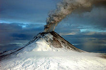
Augustine Volcano erupting on January 12, 2006.
With its myriad islands, Alaska has nearly 34,000 miles (54,720 km) of tidal shoreline. The
Aleutian Islands chain extends west from the southern tip of the
Alaska Peninsula. Many active
volcanoes are found in the Aleutians and in coastal regions.
Unimak Island, for example, is home to
Mount Shishaldin, which is an occasionally smoldering volcano that rises to 10,000 feet (3,048 m) above the North Pacific. It is the most perfect volcanic cone on Earth, even more symmetrical than Japan's
Mount Fuji. The chain of volcanoes extends to
Mount Spurr, west of Anchorage on the mainland. Geologists have identified Alaska as part of
Wrangellia, a large region consisting of multiple states and Canadian provinces in the
Pacific Northwest, which is actively undergoing
continent building.
One of the world's largest tides occurs in
Turnagain Arm, just south of Anchorage – tidal differences can be more than 35 feet (10.7 m).
[13]
Alaska has more than three million lakes.
[14]Marshlands and wetland
permafrost cover 188,320 square miles (487,747 km
2) (mostly in northern, western and southwest flatlands). Glacier ice covers some 16,000 square miles (41,440 km
2) of land and 1,200 square miles (3,110 km
2) of tidal zone. The
Bering Glaciercomplex near the southeastern border with Yukon covers 2,250 square miles (5,827 km
2) alone. With over 100,000 glaciers, Alaska has half of all in the world.
Land ownership
Alaska has more public land owned by the federal government than any other state.
[15]
Of the remaining land area, the state of Alaska owns 101 million acres (41 million hectares), its entitlement under the
Alaska Statehood Act. A portion of that acreage is occasionally ceded to organized boroughs, under the statutory provisions pertaining to newly formed boroughs. Smaller portions are set aside for rural subdivisions and other homesteading-related opportunities. These are not very popular due to the often remote and roadless locations. The
University of Alaska, as a
land grant university, also owns substantial acreage which it manages independently.
Another 44 million acres (18 million hectares) are owned by 12 regional, and scores of local, Native corporations created under the
Alaska Native Claims Settlement Act (ANCSA) of 1971.
Regional Native corporation Doyon, Limited often promotes itself as the largest private landowner in Alaska in advertisements and other communications. Provisions of ANCSA allowing the corporations' land holdings to be sold on the open market starting in 1991 were repealed before they could take effect. Effectively, the corporations hold title (including subsurface title in many cases, a privilege denied to individual Alaskans) but cannot sell the land.
Individual Native allotments can be and are sold on the open market, however.
Various private interests own the remaining land, totaling about one percent of the state. Alaska is, by a large margin, the state with the smallest percentage of private land ownership when Native corporation holdings are excluded.
Climate
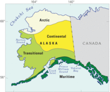
Map depicting the climate zones of Alaska.
The climate in Southeast Alaska is a mid-latitude
oceanic climate (
Köppen climate classification:
Cfb) in the southern sections and a subarctic oceanic climate (Köppen
Cfc) in the northern parts. On an annual basis, Southeast is both the wettest and warmest part of Alaska with milder temperatures in the winter and high precipitation throughout the year. Juneau averages over 50 in (130 cm) of precipitation a year, and
Ketchikan averages over 150 in (380 cm).
[17] This is also the only region in Alaska in which the average daytime high temperature is above freezing during the winter months.
The climate of
Anchorage and south central Alaska is mild by Alaskan standards due to the region's proximity to the seacoast. While the area gets less rain than southeast Alaska, it gets more snow, and days tend to be clearer. On average,
Anchorage receives 16 in (41 cm) of precipitation a year, with around 75 in (190 cm) of snow, although there are areas in the south central which receive far more snow. It is a subarctic climate (
Köppen: Dfc) due to its brief, cool summers.
The climate of
Western Alaska is determined in large part by the
Bering Sea and the
Gulf of Alaska. It is a subarctic oceanic climate in the southwest and a continental subarctic climate farther north. The temperature is somewhat moderate considering how far north the area is. This
region has a tremendous amount of variety in precipitation. An area stretching from the northern side of the Seward Peninsula to the
Kobuk River valley (i. e., the region around
Kotzebue Sound) is technically a
desert, with portions receiving less than 10 in (25 cm) of precipitation annually. On the other extreme, some locations between
Dillingham and
Bethel average around 100 in (250 cm) of precipitation.
[18]
The climate of the interior of Alaska is subarctic. Some of the highest and lowest temperatures in Alaska occur around the area near
Fairbanks. The summers may have temperatures reaching into the 90s °F (the low-to-mid 30s °C), while in the winter, the temperature can fall below −60 °F (−51 °C). Precipitation is sparse in the Interior, often less than 10 in (25 cm) a year, but what precipitation falls in the winter tends to stay the entire
winter.
The highest and lowest recorded temperatures in Alaska are both in the Interior. The highest is 100 °F (38 °C) in
Fort Yukon (which is just 8 mi or 13 km inside the arctic circle) on June 27, 1915,
[19][20] making Alaska tied with Hawaii as the state with the lowest high temperature in the United States.
[21][22] The lowest official Alaska temperature is −80 °F (−62 °C) in
Prospect Creek on January 23, 1971,
[19][20] one degree above the lowest temperature recorded in continental North America (in
Snag, Yukon, Canada).
[23]
The climate in the extreme north of Alaska is
Arctic (
Köppen: ET) with long, very cold winters and short, cool summers. Even in July, the average low temperature in
Barrow is 34 °F (1 °C).
[24] Precipitation is light in this part of Alaska, with many places averaging less than 10 in (25 cm) per year, mostly as snow which stays on the ground almost the entire year.


_AN1312003.jpg)


_AN1312003.jpg)


 Qinghai Lake or Tsongon Po (Chinese: 青海湖; Tibetan: མཚོ་སྔོན་པོ། ) is the largest lake in People's Republic of China. Located in Qinghai province on an endorheic basin, Qinghai Lake is classified as a saline and alkaline lake. Qinghai Lake has a surface area of 4,317 square km; an average depth of 21m, and a maximum depth of 25.5m as measured in 2008. [2] Both the current Chinese name "Qinghai" and the older Mongolian name Kokonor translate to "Blue Lake" or "Teal Sea", are used in English. Qinghai Lake is located about 100 kilometres (62 mi) west of the provincial capital ofXining (Tib:Ziling ཟི་ལིང་།) at 3,205 m (10,515 feet) above sea level in a depression of the Tibetan plateau.[3] Twenty-three rivers and streams empty into Qinghai Lake, most of them seasonal. Five permanent streams provide 80% of total influx.[4]

_AN1312003.jpg)